
Severe weather risk increases Tuesday night, early Wednesday
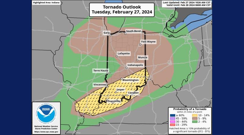
Forecasters say there is an increasing risk of severe weather in our area this evening. The National Weather Service in Indianapolis says that we now are under an enhanced risk of severe weather starting at about 9 p.m. tonight through 4 a.m. Wednesday morning.
The agency warns that several types of severe weather are possible including large hail, heavy rain, wind gusts of 60 to 70 mph and even tornadoes are possible. The greatest danger of tornadoes is from 7 tonight to midnight.
Local emergency officials are warning of the possibility of power outages.
With the increased risk of severe weather in our area, state emergency officials are offering safety tips.
The Indiana Department of Homeland Security says that if you have to take shelter, you should move to the lowest floor of a sturdy building such as a basement, safe room or storm shelter. If you don’t have such shelter, you should use an interior room or a hallway that has no windows. Blankets, pillows and furniture can provide additional protection.
If you are in a vehicle when severe weather hits, officials say your best choice is to get out and take shelter in a strong building. If you have to stay in the car, keep your seatbelt on, lower your head below the window and cover your head and neck with your arms and a blanket.
They also say not to try to shelter underneath of a bridge or overpass. Strong winds could cause the structure to collapse. You are also not protected from flying debris under a bridge. And if you vehicle is stopped there, you can block the roadway, preventing emergency crews from passing through or impeding others who are trying to reach better shelter.
The department also suggests that you have several ways of getting accurate and updated weather reports including radios and smartphone apps.