
Strong thunderstorms moving through area Sunday night
According to the National Weather Service in Indianapolis:
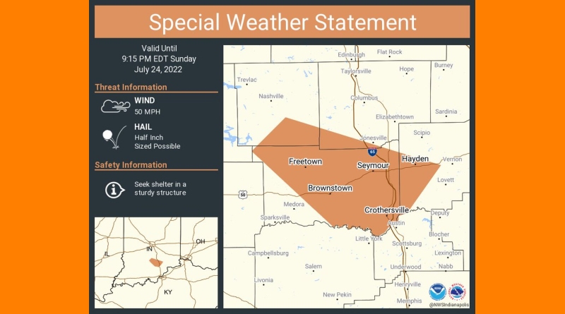
A strong thunderstorm will impact portions of southeastern Brown, southwestern Bartholomew, Jackson and southwestern Jennings Counties through 915 PM EDT…
At 822 PM EDT, Doppler radar was tracking a strong thunderstorm 11 miles south of Nashville, or 17 miles west of Seymour, moving southeast at 20 mph.
HAZARD…Wind gusts up to 50 mph and half inch hail.
SOURCE…Radar indicated.
IMPACT…Gusty winds could knock down tree limbs and blow around unsecured objects. Minor damage to outdoor objects is possible.
Locations impacted include…
Seymour, Brownstown, Crothersville, Hayden, Waymansville, Freetown, Vallonia, Spurgeons Corner, Elkinsville, Kurtz, Cortland, Stone Head and Story.
This includes Interstate 65 between mile markers 37 and 58.
PRECAUTIONARY/PREPAREDNESS ACTIONS…
If outdoors, consider seeking shelter inside a building.
Torrential rainfall is also occurring with this storm and may lead to
localized flooding. Do not drive your vehicle through flooded roadways.
Frequent cloud to ground lightning is occurring with this storm. Lightning can strike 10 miles away from a thunderstorm. Seek a safe shelter inside a building or vehicle.
A Severe Thunderstorm Watch remains in effect until midnight EDT for central, south central and southeastern Indiana.