Planting Weather Forecast: Rain Midweek, then Sunny and Dry Starting Thursday

Our first Planting Weather Forecast of the season—Presented by Beacon Credit Union—starts off with dry weather for opening weekend!
After scattered rain showers over the Great Lakes and Eastern Corn Belt on Friday, we see high pressure dominating for Saturday and Sunday. Evaporation rates should be at nearly maximum both days, although it will be a bit cooler Saturday vs. Sunday, especially in Michigan.
Monday should be mostly dry as well, but we expect clouds to build, first in Michigan, and then later in the afternoon and evening farther south into Indiana and Ohio.
A frontal boundary will try to work into the region for Tuesday and early Wednesday. Rain and thunderstorms are likely on a scattered basis with only about 40% to 50% coverage through Tuesday midday, and then more organized and heavier for Tuesday afternoon and into Wednesday morning. Rain totals will be 0.25” – 1” in Indiana and then 0.1” – 0.6” in Michigan. Wednesday afternoon and Thursday clear out in Michigan with good sunshine.
However the frontal boundary from Tuesday stalls near the Ohio River for Wednesday and Thursday. This will allow for additional moisture to work up that old boundary from the southwest. Therefore, we expect another half to 1.5” of rain from Wednesday afternoon through sunrise Friday in areas from U.S. 24 southward. Some action overnight Thursday night may even lift far enough norths to get into SE MI between Midnight and then sunrise Friday.
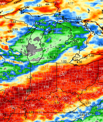
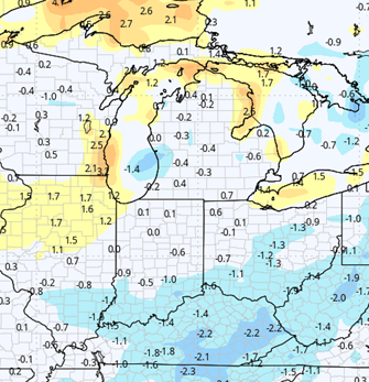
The rest of the week and weekend turn out partly sunny and dry. We will keep dryness into Monday the 5th. However, the area to our west looks rather active. The map below shows cumulative 10-day rain potential for the region.
Extended Period:
The extended period features a very active central to western corn belt, upper Midwest and Great Plains. Some of that eventually will work into our region. At this point the 6th should stay dry, but see an increase in clouds late. Scattered showers associated with a strong front to the west will make a few incursions here for the 7th and early the 8th. However, coverage looks to be no better than 40%.
The front itself finally shows up for Thursday afternoon and early Friday, the 8th and 9th. Rain totals can be 0.25” – 0.75” with coverage at 100% of both IN and MI. we should go back drier behind that front, but may see some lingering clouds into Saturday the 10th. Sunday the 11th starts a drier pattern, with very little action to star the following week to the west.
Weeks 3 & 4:
Weeks 3 and 4 stay near normal on temps and precipitation both. This means we should see opportunities each week with 3-4 day windows opening up, but still getting some moisture as we go along. This also suggests that we do not see overly heavy rain events when they do happen into the latter part of May.
Week 3
Precipitation (green: above normal, brown: below)
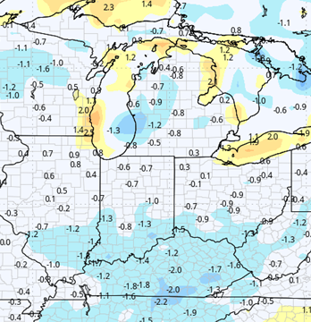
Temperatures (blue: below normal, orange: above)
Week 4
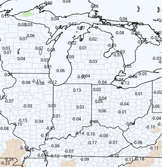
Precipitation (green: above normal, brown: below)
Temperatures (blue: below normal, orange: above)