Planting Weather Forecast: A Dry Stretch, But Rain Returns Midweek

We are dry to kick off the weekend, and it’s a dryness that has a little bit of a chill to it in our Planting Weather Forecast—presented by Beacon Credit Union.
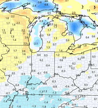
High pressure is going to be working across the Great Lakes region and that will bring sunshine through the entirety of Saturday and Sunday, but we will be seeing temperatures just a little bit below normal period however evaporation is going to be at nearly a maximum and we should see fast drying with a little bit of a West and northwest breeze. The dry pattern continues on through the first half of this coming week.
Monday, Tuesday, and Wednesday all will feature partly to mostly sunny skies and the difference over the weekend will be that south winds take control allowing temperatures to climb.
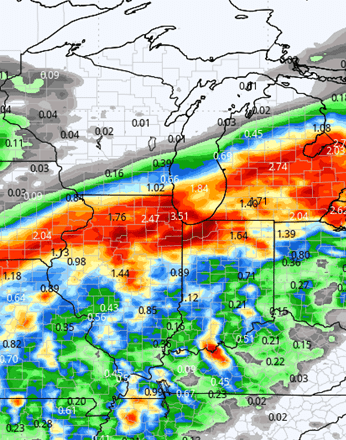
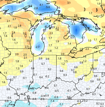
We do see our next frontal boundary starting to work in here as we move into the middle part of the week. Rain starts in Western Michigan likely mid to late morning on Wednesday and then clouds actually will increase Wednesday afternoon in Indiana, with scattered showers and thunderstorms likely making an appearance Wednesday night into early Thursday. At this point we are looking at rain totals to be from anywhere from 1/2 inch to about 2.5” coverage at 90% of the region. Thunderstorms will be less likely in southern Indiana than northern Indiana and Michigan, and the heavier rain totals will follow the thunderstorm potential. The map below shows potential at midweek.
Behind that front we do see a dry finish to the week Thursday night, Friday, Saturday, and Sunday all will be dry. We see daytimes that are filled with sunshine and nighttime temperatures that are near normal period evaporation rates stay at a near maximum that is about 1/3 of an inch of moisture per day and drying will be swift to finish the week.
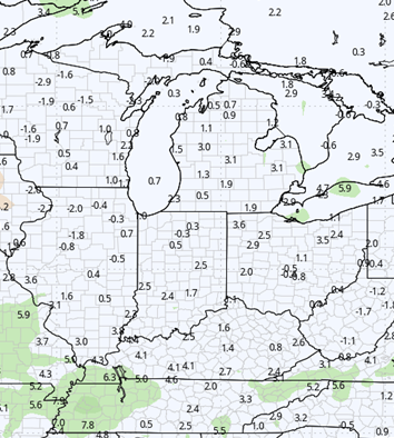
The week of the 9th with our next weather system trying to show up that is going to bring rain and thunderstorms for Monday and an unsettled pattern through Tuesday and Wednesday. Rain totals are still a little bit up in the air but right now we expect anywhere from .25”-1” of potential with coverage around 80% of the region on Monday.
![]()
Extended Period:
The extended weather forecast period continues with a rather unsettled pattern. For Tuesday the 10th Wednesday the 11th and Thursday the 12th we all see hit and miss scattered showers and thunderstorms moving through Indiana and Michigan well the eastern corn belt in general. What this is going to do is keep us in a 50 to 60% coverage area for each day. And we will end up with rain totals anywhere from half to two inches combined over the three-to-four-day stretch.
Now as we move into the later part of the week (this is going to be for Friday the 13th and into Saturday the 14th) we do see a stronger well put together area of low pressure coming out of the central plains and western corn belt. That could bring us another round of strong to severe weather. Overall, the extended pattern it does pick up moisture quite a bit and we will be looking at a very moist middle of the month of June.
Weeks 3 & 4:
Weeks 3 and 4 will turn out mostly near normal on precipitation that doesn’t mean we don’t see showers thunderstorms we’re just going to be close to normal for the second-half of June period on the temperature side of things we are continuing to look for a bump in temperatures it will be relatively slow but we are expecting temperatures to be normal to just a bit above normal both in week 3 and in week for. Where we do see a little bit of a lag in that will be in southern parts of Indiana the Ohio Valley and then down into the Deep South there we see especially in Kentucky and Tennessee temperatures that are well below normal.
Week 3
Precipitation (green: above normal, brown: below)
Temperatures (blue: below normal, orange: above)
Week 4
Precipitation (green: above normal, brown: below)
Temperatures (blue: below normal, orange: above)