
Moisture May Pause Harvest on Halloween
As harvest is getting close to wrapping up for 2024, we finally are getting what some would call a more “normal” Seed Genetics Direct Harvest Weather Forecast—you know, one that has some moisture and requires us to work around delays and showers that work through the Great Lakes and Eastern Corn Belt.
After October ends as one of the driest months on record, we get a rather damp start to November. But still, we only really have this one “good” threat of moisture over the next 10 days, which comes on Halloween.
This weekend will be cool and dry. After the minor scattered showers and storms that came through parts of the region early Friday morning into Friday midday, we are looking at cool, Canadian air settling southward over the Great Lakes and eastern corn belt. High pressure will dominate, so that means full sunshine and good drying. Once we get on the backside of that high, likely Monday morning, we expect strong southwest flow to take over, giving significant warming.
We will be breezy for the Monday through Wednesday period, quite windy for Tuesday. The pattern will allow for very warm air to be here on Tuesday, as temps can easily run into the upper 70s and low 80s. The exceptional warmth may trigger a few scattered showers in MI Tuesday, but farther south and east we are going to remain dry. Monday and Wednesday everybody is precipitation free.
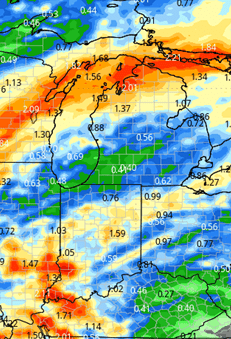
A strong cold front works into the forecast for Thursday (Halloween). This front will bring potential for showers and thunderstorms. But the better threat of thunderstorms seems to set up farther west initially. We will pencil in .25”-1” rain totals from the Halloween frontal passage with 100% coverage. We take a break for Friday, Nov. 1 and the start of the weekend, but then a second system really gathers strength in the plains and western corn belt Saturday midday, kicking out to the east Saturday afternoon through Sunday early morning. That second system can bring another .25”-1.5” to 100% of our region.
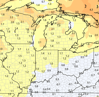
So, if you’re keeping score at home…that is 8 weeks of basically nothing, and then – BAM – 2 strong systems in 3.5 days. Ain’t mother nature grand! The map below shows combined rain totals for IN and MI from next Thursday through Sunday midday (Oct. 31 to Nov. 3).
We swing back to a drier pattern behind that last system for Sunday afternoon and into the start of the week of Nov. 4, but are watching a system developing in the northern Rockies to start that week that likely makes an appearance in our extended outlook.
Extended Period:
Oure extended 11-16 day period looks cooler. Canadian air seems to want to take more controls through the entirety of the period. What we are seeing with this outlook is a bit more active on precipitation as well, as the jet stream digs out a trough over the eastern part of the US. That should allow for a bit of moisture later from the 6th into the 7th, and then more clouds and lake effect precipitation behind that system. To be clear, we are not looking at bitter cold, but we should see temps back a lot closer to normal, and more of a damp feel, or at least slower dry down times.
Weeks 3 & 4:
Precipitation still looks to hold near normal for the week three and week four periods, even sneaking a bit above normal in parts of northern Indiana in week four. Temps are remaining warmer than normal, but seeing the levels drop weekly, which really backs up our thought that cooler Canadian air is going to start winning out more in the weeks ahead.
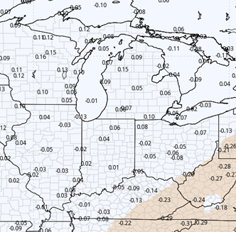
Week 3
Precipitation (green: above normal, brown: below)
Temperatures (blue: below normal, orange: above)
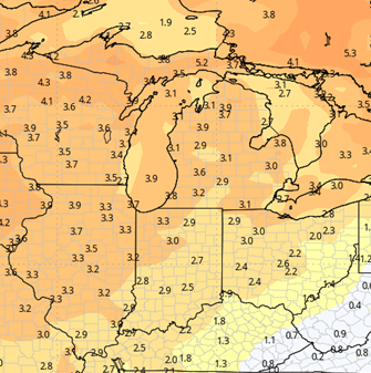
Week 4
Precipitation (green: above normal, brown: below)
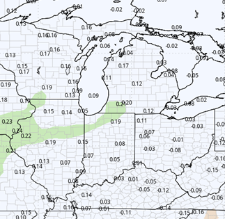
Temperatures (blue: below normal, orange: above)