
Major flooding continues on area rivers; Jonathan Moore Pike closed in west Columbus
Note: This story will be updated
Flood warnings are in effect for rivers and streams in our area, as newly falling rain adds on to the after effects of Wednesday night’s storms.
Flood warnings are in effect until further notice and many have been extended in duration as rain continues to fall.
Overnight, East Fork White River at Columbus and Seymour entered the major flood stage. Flood waters aren’t expected to drop back to the moderate level in Seymour until Tuesday morning. The river is currently forecast to crest today at about two feet below record flood levels.
Overnight residents in the hardest hit neighborhoods were encouraged to evacuate until the water recedes including those in Garden City, Walesboro, Bethel Village, Southern Crossing, South Gladstone, County Road 325W, Lowell Road, and State Road 46 .
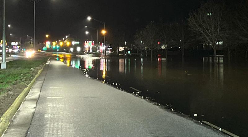
East Fork White River at Columbus continues to rise and has risen to the major flood stage this morning Flood gauges predict the river will crest this evening at about 6 inches below the record-setting flood level of 2008. According to Columbus Police, the city is now cutoff between the downtown area and western Columbus, with State Road 46/Jonathan Moore Pike now closed in both directions between State Road 11/Jonesville Road SR46 to Goeller Blvd with water over the roadway. This includes Interstate 65 exits/ramps at State Road 46. State Road 11 also closed yesterday between Columbus and Walesboro.
Yesterday, the Indiana Department of Transportation made the decision to reopen U.S. 31 at the Jackson/Bartholomew County line to allow more access to Columbus. The highway had been closed since early last week so crews could begin a bridge project there.
Columbus Regional Hospital yesterday lifted its flood gates as a precaution. The gates were installed in the aftermath of the 2008 flood, during which the hospital was seriously damaged by the rising Haw Creek.
There were also many water rescues in area communities as drivers continue to drive around barricades and road closing signs, and then their vehicle gets stuck in the floodwaters. Authorities urge everyone to obey any road closings you come across. The National Weather Service says six inches of moving water is enough to knock adults off their feet, a foot of water can sweep away a car and two feet can carry off an SUV or pickup. They urge you to turn around and don’t drown.
Emergency officials in Bartholomew County also warned over night that there is a danger of a failure of the dam near Youth Camp Road. Shannan Cooke, head of Emergency Management for the county explained that the dam is leaking and a pump is currently working to help pump water levels from the lake down and reduce pressure on the dam. Youth Camp is following their emergency plan. That includes notifying residents, local officials, and calling for a Flash Flood Watch a request for the Flash Flood Watch. Cooke said the watch gives residents downstream area a heads up to prepare for evacuation. She said the need to continue the watch will be reevaluated this morning. .
As of 7:30 a.m. Sunday morning, area rivers with major flooding:
- East Fork White River at Columbus: Major flooding at 16.5 feet, half a foot above the 16 foot major flood stage. The river is expected to crest at 17.9 feet this evening, below the 18.6 foot record flood level.
- East Fork White River at Seymour: Major flooding at 19.6 feet, half a foot above the 19 foot major flood stage. The river is expected to crest at 19.9 feet early Monday, about a foot below the 21 foot record flood level.
- Big Blue River at Shelbyville: Major flooding a 19.95 feet, almost two feet above the 18 foot major flood stage and a few inches below the record flood level of 20.2 feet. The river should be cresting momentarily.
Area rivers with moderate flooding.
- Flatrock River at Columbus: Moderate flooding at 16.2 feet, 1.2 feet above the moderate flood level of 15 feet. The river is expected to crest this afternoon in the moderate flood stage.
- Flatrock River at St. Paul: Moderate flooding at 10.7 feet, .7 feet above the moderate flood stage. The river is expected to crest soon in the moderate flood stage.
- Flatrock River at Rushville: Moderate flooding at 15.2 feet, .2 feet above the moderate flood stage. The river has already crested and is expected to return to minor flooding momentarily.
- Driftwood River at Edinburgh: Moderate flooding at 16.4 feet, 2.4 feet above the moderate flood level. The river is expected to crest by this evening right at 17 feet, which is also the major flood level.
- Sugar Creek at Edinburgh: Moderate flooding at 16.5 feet, 2.5 feet above the moderate flood level. The river is expected to crest in the moderate flood stage later today.
Haw Creek is no longer flooding at Hope, Clifford or Columbus. Clifty Creek is also no longer flooding. Muscatatuck River at Vernon never reached the minor flood stage.
You can find more details on river flooding on our website here: https://1010wcsi.com/weather-forecast/#flooding
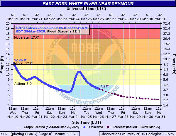
Photo: Jonathan Moore Pike flooding overnight. Photo provided by Columbus Police Department.